(NEW YORK) — It has been a tale of two winters on the opposing U.S. coasts this season.
While the East has been slammed with frigid temperatures and punishing winter storms, the West is experiencing a snow drought amid warmer-than-normal temperatures.
Prolonged drought across much of the West has been worsened this winter by below‑average snowfall and persistent warmth, fueling a widespread and intensifying snow drought. With sharply reduced mountain snowpack, the region’s water supplies and winter tourism are facing mounting challenges, experts told ABC News.
“This winter, we’ve just had an extreme lack of storm activity, and the storms that we have had have either brought very small amounts of snowfall or have brought rain,” Jon Meyer, assistant Utah state climatologist, told ABC News.
Warm temperatures have prevented snow from accumulating
Much of the western United States entered winter already grappling with a lack of rain. Widespread moderate to severe drought conditions stretched from New Mexico to Washington, including much of the Colorado River Basin, leaving soil moisture low and reservoir levels depleted heading into the season.
More than one-third of the West is currently facing some form of drought condition, with much of Utah, Colorado and New Mexico experiencing a moderate drought or worse, according to the U.S. Drought Mitigation Center’s U.S. Drought Monitor.
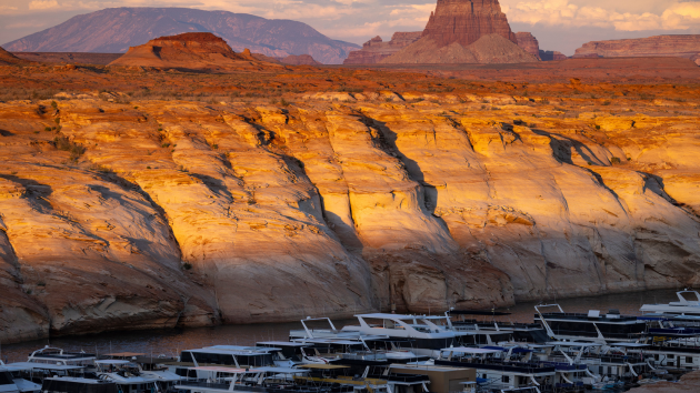
Utah is facing the worst drought conditions among western states, with more than 94% of the state experiencing what the USDM categorizes as a Moderate Drought and more than 40% of the state experiencing Severe Drought.
Salt Lake City has only received a tenth of an inch of snow so far this season – the lowest to date since records began in 1874, according to the National Weather Service. Their lowest seasonal snowfall was 14.3 inches during the winter of 1933-34. By comparison, parts of the Southeast, which typically don’t see much snowfall, have seen more snow than Salt Lake City this season.
“Just totally uncharted territory for the amount of low-elevation and mid-elevation snowfall Utah has seen, and that’s a pattern that’s played out across much of the Western U.S.,” Meyer said.
While many western states received average or above-average precipitation in the fall and early winter, warmer temperatures caused much of it to fall as rain rather than snow, leading to unusually low snowpack and a rapidly developing snow drought.
“If you look at most of the West, it’s at or above average, with regards to precipitation to date,” Eric Sproles, an associate professor of earth sciences at Montana State University, told ABC News. “But if you look at the the amount of water that’s stored in the snow pack is, it’s pretty bleak.”
Meteorological winter, which begins in the U.S. on December 1, kicked off with record warmth across much of the West. December 2025 was the warmest December on record for cities including Phoenix and Tucson, Arizona; Las Vegas, Nevada; Salt Lake City, Utah; Albuquerque, New Mexico; Portland, Oregon and Boise, Idaho, according to the National Oceanic and Atmospheric Administration (NOAA).
Nine western states – Arizona, California, Colorado, Nevada, New Mexico, Oregon, Utah, Washington and Wyoming – recorded their warmest December on record. For the winter season to date, Colorado is currently experiencing its warmest winter since 1934, while Utah is experiencing its warmest winter on record, according to NOAA.
The snow drought is threatening water supplies
Drought on its own already stresses water supplies, agriculture and ecosystems. But when winter fails to deliver significant mountain snow, the resulting snow drought – a period of abnormally little snowpack for the time of year – can intensify those impacts, according to NOAA.
The snowpack typically acts as a natural water reservoir. However, without an adequate snowpack to slowly release water through the spring and summer snow melt, rivers run lower, soils dry out earlier, and drought conditions can deepen and linger.
Melting snow provides a slow release of the water into reservoirs and dams but also recharges ground water as well, Sproles said: “That slow, steady release is important. The snowpack is kind of like a savings account.”
In Utah, the snow water equivalent – meaning how much water is in the snowpack – is currently at only 55% of its median, which is the lowest snow water equivalent to date. Moreover, only a quarter of the state has seen a ground snow cover depth of at least 1 inch.
Colorado and Oregon are also reporting their lowest snow water equivalents to date, with Montana approaching its lowest snow water equivalent to date.
In much of the West, snowmelt provides a large percentage of the water used by communities, agriculture, and ecosystems; in some states, up to about 75 percent of the water supply can come from melting snow, according to the U.S. Geological Survey. As such, the snow water equivalent is a vital measure of the region’s water resources.
According to NOAA, a persistent snow drought can trigger a cascade of hydrologic changes. Low snowpack and early snowmelt can affect vegetation, reduce surface and subsurface water storage and alter streamflow, all of which directly impact water management and planning across the West.
While soil moisture in not currently a concern, it could dry out over the next couple of months, according to Meyer.
“We’ve become critically reliant on soil moisture observations for drought monitoring and predictions,” Meyer said.
The reservoirs along the Colorado River are especially threatened, the experts said. Major reservoirs in the Colorado River Basin remain well below average, according to latest figures from the U.S. Bureau of Reclamation (USBR). As of early February, Lake Powell, in southern Utah and northern Arizona, was about 26 % full, while Lake Mead – the nation’s largest reservoir by volume, located in Arizona and Nevada – was about 34% full.
Total storage in the Colorado River system, which provides water for more than 40 million people and fuels hydropower resources in seven western states, was roughly 37% of capacity, down from about 42% at the same time last year, according to the USBR, which has flagged 13 reservoirs, the majority located in the West, for having the lowest observed water storage levels for the current time period.
The Colorado River system also serves as a vital resource for 30 tribal nations, sustaining 5.5 million acres of farmland and agricultural communities throughout the West, while also supporting critical ecosystems and protecting endangered species, the USBR said.
Winter sports have been impacted by lack of snow
The snow drought is also impacting local economies that rely on winter sports, an industry that contributes $20 billion annually to the U.S. economy, according to The Climate Reality Project.
“The resort winter tourism is a huge economic backbone for many of these mountain resort communities,” Marcene Mitchell, senior vice president for climate change for the World Wildlife Fund, told ABC News. “And so as they lose their snowfall, they also lose these revenue.”
Vail Resorts, a Colorado-based company that owns and operates some of the largest ski resorts in North America, reported in January that skier visits to its North American resorts were down about 20% through Jan. 4, compared to the same period last year. The company issued the update as a mid-season report on skier visits and revenue, citing a lack of early-season snowfall as a major factor in the decline.
Season-to-date total lift revenue, including an allocated portion of season pass revenue, was down 1.8% from the same period last year, said the tourism company, which operates dozens of resorts across North America, including Vail Mountain and Breckenridge in Colorado and Park City Mountain in Utah.
“We experienced one of the worst early season snowfalls in the western U.S. in over 30 years, which limited our ability to open terrain and negatively impacted visitation and ancillary spending for both local and destination guests during the period,” Chief Executive Officer Rob Katz said in a statement.
Vail’s Tahoe-area resorts in California also had a slow start through mid-December, but holiday-period snowstorms allowed the company to open more terrain, Katz said.
February and March typically can bring significant amounts of snow to the region, and odds favor above-average precipitation for much of the region over the next few weeks, according to NOAA’s Climate Prediction Center, with persistent unusually warm conditions less likely. However, NOAA notes, snowfall in the coming months may not be able to make up for existing deficits.
Forecasters further caution that this pattern may not last for the rest of the month, with overall warmer and drier-than-average conditions still favored for the month as a whole.
Copyright © 2026, ABC Audio. All rights reserved.