• Extreme Cold Warning - Click for Details
    ...EXTREME COLD WARNING REMAINS IN EFFECT FROM 4 AM SATURDAY TO 1 PM EST SUNDAY...
    Expires: February 08, 2026 @ 1:00pm
    WHAT
    Dangerously cold wind chills as low as 20 to 35 below zero expected.
    WHERE
    Portions of central New York and northeast Pennsylvania.
    WHEN
    From 4 AM Saturday to 1 PM EST Sunday.
    IMPACTS
    The dangerously cold wind chills as low as 35 below zero could cause frostbite on exposed skin in as little as 30 minutes.
    ADDITIONAL DETAILS
    The coldest wind chills are expected over the exposed, higher elevations Saturday morning and again Saturday night into Sunday morning. Northwest winds will be gusting between 30 to 45 mph at times on Saturday. Isolated power outages are possible.
    PRECAUTIONARY/PREPAREDNESS ACTIONS
    Dress in layers including a hat, face mask, and gloves if you must go outside or are traveling. To prevent water pipes from freezing; wrap or drain or allow them to drip slowly. Keep pets indoors as much as possible.
  • Winter Weather Advisory - Click for Details
    ...WINTER WEATHER ADVISORY IN EFFECT UNTIL 7 AM EST SUNDAY...
    Expires: February 08, 2026 @ 7:00am
    WHAT
    Snow. Additional snow accumulations between 2 and 5 inches. Northwest winds gusting as high as 45 mph.
    WHERE
    Cortland, Onondaga, Seneca, Southern Cayuga, and Tompkins Counties.
    WHEN
    Until 7 AM EST Sunday.
    IMPACTS
    Plan on slippery road conditions. Areas of blowing snow could significantly reduce visibility. The hazardous conditions could impact the Friday evening commute.
    ADDITIONAL DETAILS
    The steadiest snow will fall this evening and tonight. Saturday into Saturday night will feature narrow bands of lake effect snow along with significant blowing and drifting snow across the area.
    PRECAUTIONARY/PREPAREDNESS ACTIONS
    Slow down and use caution while traveling. The latest road conditions for the state you are calling from can be obtained by calling 5 1 1. Be prepared for slippery roads. Slow down and use caution while driving. If you are going outside, watch your first few steps taken on stairs, sidewalks, and driveways. These surfaces could be icy and slippery, increasing your risk of a fall and injury.

WGVA 106.3FM 1240AMMix 98.5101.7 The WallWFLR Finger Lakes Country Classic Hits 99.3The Lake 100.1/104.5 WAUB 96.3FM 1590AM

As the West warms up, the East stays cold

SHARE NOW

(NEW YORK) — As a deep freeze continued Tuesday from the Northeast to the Southeast, Southern California and other parts of the West are expected to see another day of balmy weather.

Some areas in the West are poised to break daily high temperature records. Burbank, California, is expected to hit 87 on Tuesday and Long Beach could hit 89.

Other parts of the West, including San Diego, Portland, Oregon, and Great Falls, Montana, could also surpass daily record-high temperature records on Tuesday.

On Monday, several cities in the West set new daily high temperature records, including Escondido, California, which hit 92 degrees, and Phoenix, Arizona, which saw temperatures climb to 85.

The warm weather in the West is expected to continue on Wednesday. While not expected to see a record-breaking daily temperature, Los Angeles is forecast to reach 89 degrees.

Wind advisories are in place for parts of Southern California, especially along the mountain ranges from southeast Los Angeles down to the Mexico border. San Bernardino, Riverside, Corona and Anaheim are expected to see gusts up to 45 mph and isolated gusts of up to 55 mph from 4 a.m. Pacific time on Wednesday through noon on Thursday.

The warm weather in the West will slowly spread through the middle of the country next week.

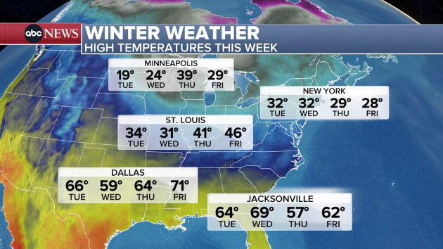
Meanwhile, some areas of Florida will get a break from the cold before cooler temperatures return on Thursday and Friday. Orlando is forecast to top 70 on Wednesday.

Much of Florida remained under a freeze warning on Tuesday morning. A cold weather advisory was also in place for Miami.

On Monday, several cities throughout the Southeast set daily low temperature records, including Gainesville, Florida, which recorded a low of 22; Fayetteville, Arkansas, which saw the temperature plummet to 12; and Greensboro, North Carolina, which got down to 3.

Freezing temperatures are expected to continue in other parts of the East and Northeast this week as another cold blast is expected on Wednesday, Thursday and into the weekend.

Copyright © 2026, ABC Audio. All rights reserved.

Get the latest Finger Lakes headlines and stories every morning FREE in your email! Subscribe today!