(NEW YORK) — At least 100 million Americans are on alert for dangerous cold weather in the coming days across the East as brutal, eye-watering cold winds — the coldest of the season for some — are expected across the Northeast this weekend.
Wind chills in the -20s are possible in Michigan and northern Ohio through Saturday morning, with -10s for southern Ohio and West Virginia.
Richmond, Virginia, could reach below-zero wind chills this weekend.
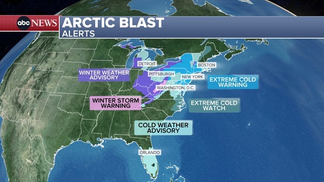
Extreme cold warnings are in place across much of the Northeast, including Pennsylvania, New Jersey, New York, Connecticut, Massachusetts and Vermont.
New York City could reach as low as -20 this weekend, and upstate New York around Saranac Lake could reach -40. Frostbite can occur in 10 minutes on exposed skin.
Much of this extreme cold is due to strong winds gusting 30 to 50 mph this weekend, especially Saturday.
Monday morning will still be very cold across the Northeast, but the wind will be calmer, so wind chills won’t be as extreme.
Slowly through the week, a warming trend is expected across the East, with high temperatures going above freezing for New York City and Boston on Wednesday, possibly even on Tuesday.
The end of next week is looking above average across the middle of the country, while the Northeast feels seasonal mid-February winter temperatures.
The system ushering in the brutal cold also brings some snow.
Friday morning, snow was falling over Michigan, Indiana, Ohio, West Virginia, western Pennsylvania and western New York.
By Friday afternoon, snow will become more scattered and fall from the Appalachians of western North Carolina through upstate New York.
A few light snow showers or flurries will pass over New York City on Friday night, and much of Saturday is looking dry. A dusting up to 1 inch of snow is possible over the city on Friday night.
On Saturday, Boston and much of New England will continue to see passing snow showers.
Boston could see 2 to 4 inches of snow through Saturday evening.
The western New York I-90 corridor could see 2 to 5 inches of snow through Saturday evening, including Syracuse, Rochester and Buffalo.
Copyright © 2026, ABC Audio. All rights reserved.