• Extreme Cold Warning - Click for Details
    ...EXTREME COLD WARNING REMAINS IN EFFECT FROM 4 AM SATURDAY TO 1 PM EST SUNDAY...
    Expires: February 08, 2026 @ 1:00pm
    WHAT
    Dangerously cold wind chills as low as 20 to 35 below zero expected.
    WHERE
    Portions of central New York and northeast Pennsylvania.
    WHEN
    From 4 AM Saturday to 1 PM EST Sunday.
    IMPACTS
    The dangerously cold wind chills as low as 35 below zero could cause frostbite on exposed skin in as little as 30 minutes.
    ADDITIONAL DETAILS
    The coldest wind chills are expected over the exposed, higher elevations Saturday morning and again Saturday night into Sunday morning. Northwest winds will be gusting between 30 to 45 mph at times on Saturday. Isolated power outages are possible.
    PRECAUTIONARY/PREPAREDNESS ACTIONS
    Dress in layers including a hat, face mask, and gloves if you must go outside or are traveling. To prevent water pipes from freezing; wrap or drain or allow them to drip slowly. Keep pets indoors as much as possible.
  • Winter Weather Advisory - Click for Details
    ...WINTER WEATHER ADVISORY IN EFFECT UNTIL 7 AM EST SUNDAY...
    Expires: February 08, 2026 @ 7:00am
    WHAT
    Snow. Additional snow accumulations between 2 and 5 inches. Northwest winds gusting as high as 45 mph.
    WHERE
    Cortland, Onondaga, Seneca, Southern Cayuga, and Tompkins Counties.
    WHEN
    Until 7 AM EST Sunday.
    IMPACTS
    Plan on slippery road conditions. Areas of blowing snow could significantly reduce visibility. The hazardous conditions could impact the Friday evening commute.
    ADDITIONAL DETAILS
    The steadiest snow will fall this evening and tonight. Saturday into Saturday night will feature narrow bands of lake effect snow along with significant blowing and drifting snow across the area.
    PRECAUTIONARY/PREPAREDNESS ACTIONS
    Slow down and use caution while traveling. The latest road conditions for the state you are calling from can be obtained by calling 5 1 1. Be prepared for slippery roads. Slow down and use caution while driving. If you are going outside, watch your first few steps taken on stairs, sidewalks, and driveways. These surfaces could be icy and slippery, increasing your risk of a fall and injury.

WGVA 106.3FM 1240AMMix 98.5101.7 The WallWFLR Finger Lakes Country Classic Hits 99.3The Lake 100.1/104.5 WAUB 96.3FM 1590AM

Coldest air of the season, snow to hit parts of the Northeast

SHARE NOW

(NEW YORK) — Before temperatures get warmer in the East next week, brutal cold is expected this weekend — the coldest of the season, so far, for parts of the Northeast.

Some of the coldest areas will also see accumulating snow to usher in the arctic blast.

On Friday morning, a quick snow shower will move through Michigan, Indiana and Ohio, blanketing the states in a dusting to 2 inches of snow.

Friday afternoon, snow will fall from eastern Kentucky through western Pennsylvania.

On Friday evening, scattered snow will be across Appalachia, from the Smoky Mountains to upstate New York. Up to 2 inches of snow is possible for Pittsburgh, Pennsylvania.

On Saturday, snow will fall over New England — mainly for all areas north of New York City — though some flurries or light snow may reach the city, leading to a dusting to an inch of snow there. Boston could see an inch or two of snow.

Higher snow totals are expected in New England, where 2 to 4 inches are possible for the eastern I-90 corridor, including Syracuse, Rochester, Buffalo, Erie to near Cleveland.

This low to moderate impact winter storm will usher in another cold blast along with very windy conditions leading to brutal wind chills across the region.

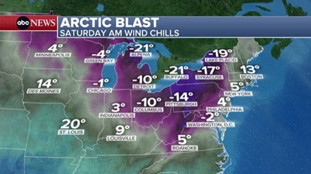
These same areas seeing the most snow will also be under strong wind gusts, with wind chills plummeting to 30 below zero. An extreme cold watch is in place from Friday night through Sunday morning.

In parts of northeastern New York, such as Lake Placid and Saranac Lake, wind chills could drop to -35 degrees, which would cause frostbite on exposed skin in as little as 10 minutes.

High temperatures in New York City will only reach the 20s on Saturday and the teens on Sunday. The lows will drop into the single digits for Sunday morning. Wind chills during the daytime this weekend will be mainly at or below zero due to gusts up to 50 mph on Saturday and gusts up to 30 mph on Sunday. Sunday morning wind chills could reach -15 in the city.

Boston and Buffalo, New York, could feel like the negative teens on Sunday morning and the negative single digits on Monday morning.

Next week, a slow pattern change is expected, with average to even above average temperatures possible for the East by the middle and end of next week. It will still be chilly, but given the brutal cold we have all been enduring, it might feel downright balmy.

Copyright © 2026, ABC Audio. All rights reserved.

Get the latest Finger Lakes headlines and stories every morning FREE in your email! Subscribe today!